Environment in Afghanistan
/ 7 min read
1. Air Pollution
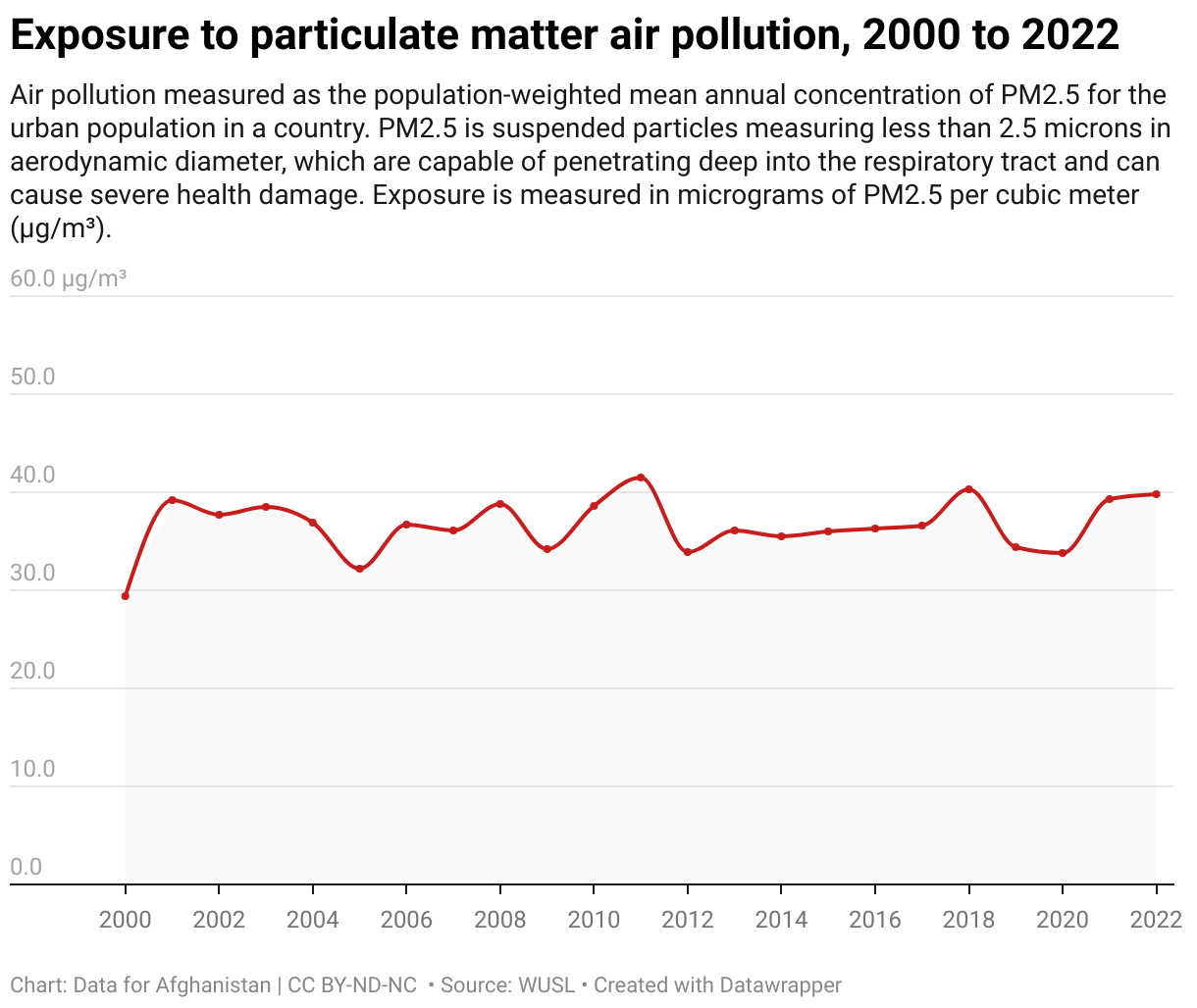
- Over the 22 years from 2000 to 2022, Afghanistan's exposure to particulate matter has shown considerable fluctuation, with no consistent downward trend. This indicates ongoing challenges in managing air pollution, with significant variability that could be influenced by both natural and human-induced factors.
- The World Health Organization (WHO) recommends that annual average concentrations of PM2.5 should not exceed 5 micrograms per cubic meter (µg/m³).
- Levels of 35 µg/m³ or higher for 24 hours can cause problems for people with pre-existing health conditions issues like asthma.
- Long-term exposure to PM2.5 levels above 10 µg/m³ is associated with increased mortality rates, cardiovascular and respiratory diseases, and lung cancer.
Cite this work:
Data for Afghanistan. (2024). Exposure to particulate matter air pollution, 2000 to 2022 [Data visualization]. https://dataforafghanistan.org/posts/environment/#1-air-pollution Licensed under CC BY-ND-NC 4.0.
2. Natural Disasters
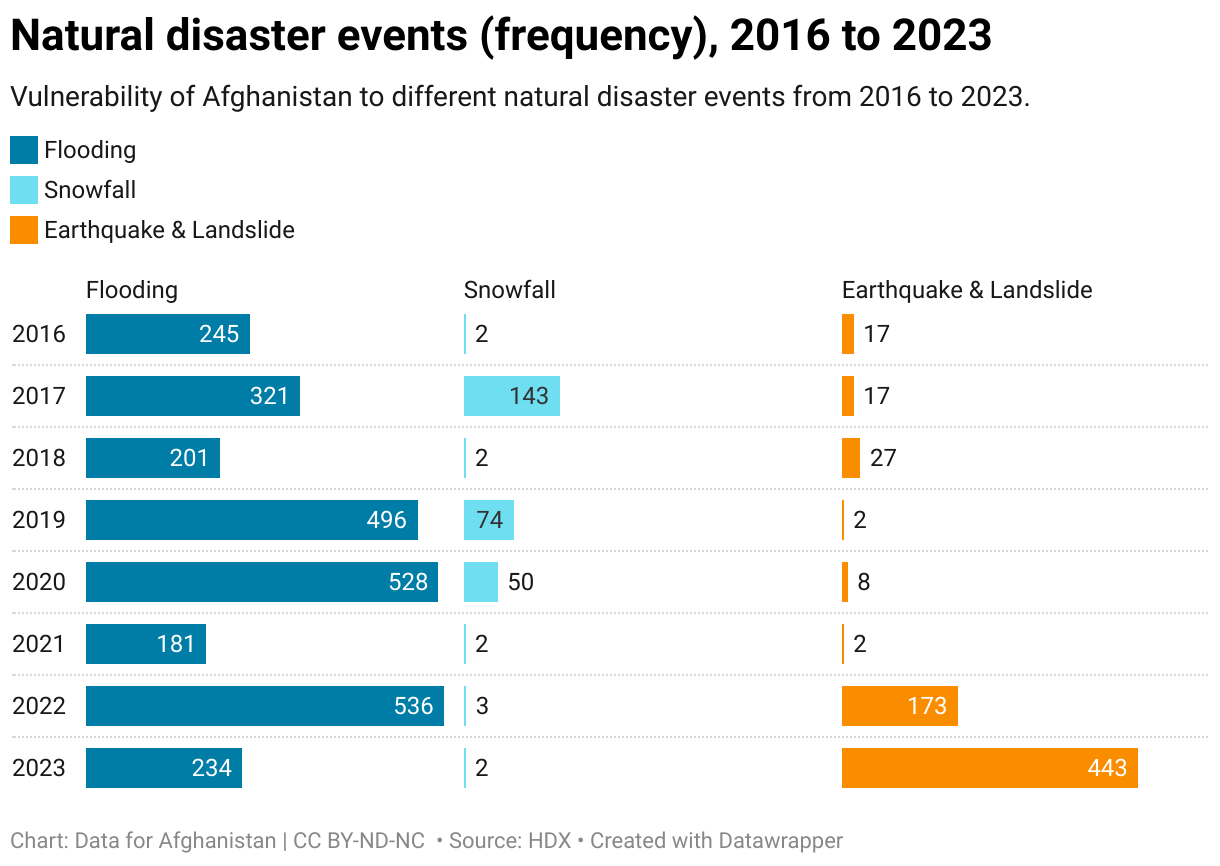
- Flooding remains a consistent natural disaster in Afghanistan, with significant fluctuations in frequency. The number of flooding events peaked at 536 in 2022, followed by a sharp decrease to 234 in 2023.
- While generally low in occurrence, snowfall events reached a peak of 143 recorded events in 2017, indicating a rare and significant weather anomaly during that year.
- Afghanistan faced a dramatic increase in earthquake frequency, rising from just 17 events in 2016 to an alarming 443 in 2023. This spike indicates a significant escalation in seismic activity over the past few years.
Cite this work:
Data for Afghanistan. (2024). Natural disaster events (frequency), 2016 to 2023 [Data visualization]. https://dataforafghanistan.org/posts/environment/#2-natural-disasters Licensed under CC BY-ND-NC 4.0.
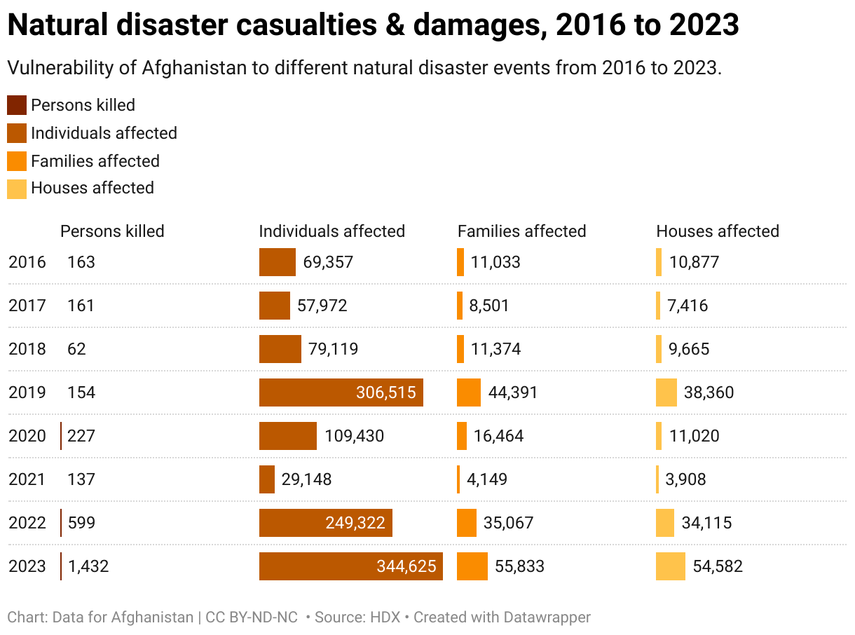
- The number of fatalities due to natural disasters has escalated dramatically, with 1432 people killed in 2023, a stark rise from 163 in 2016. This alarming trend underscores the growing severity and impact of natural disasters in Afghanistan.
- The number of individuals and families affected by natural disasters has also seen a significant increase. In 2023, 344,625 individuals and 55,833 families were affected, marking the highest numbers in the observed period and reflecting the broader impact of disasters on the Afghan population.
- The number of houses affected by natural disasters peaked in 2023, with 54,582 homes damaged or destroyed. This represents a significant increase compared to previous years, highlighting the extensive damage and potential displacement caused by these events.
Cite this work:
Data for Afghanistan. (2024). Natural disaster casualties & damages, 2016 to 2023 [Data visualization]. https://dataforafghanistan.org/posts/environment/#2-natural-disasters Licensed under CC BY-ND-NC 4.0.
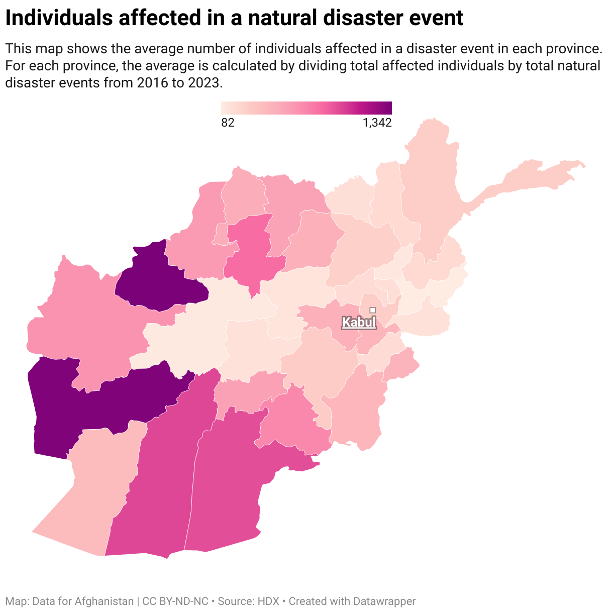
- The average number of individuals affected per event varies widely across Afghanistan. Provinces like Badghis (1,342) and Farah (1,321) have experienced significantly higher average impacts per event compared to provinces such as Ghor (98) and Kunar (82).
- Provinces like Hilmand (963) and Kandahar (937) also show high average impacts, reflecting the intense vulnerability of these southern and western regions to natural disasters.
- The province of Parwan, with 180 average individuals affected per event, stands as the median. Badghis has the highest average at 1,342, while Kunar has the lowest at 82. The median is found by ordering the provincial impact values and identifying the middle value.
Cite this work:
Data for Afghanistan. (2024). Individuals affected in a natural disaster event [Data visualization]. https://dataforafghanistan.org/posts/environment/#2-natural-disasters Licensed under CC BY-ND-NC 4.0.
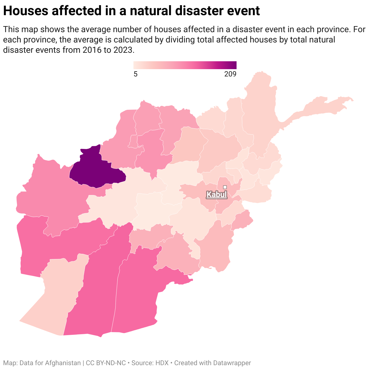
- The average number of houses affected per event varies considerably across provinces. Badghis (209 houses) and Hilmand (129 houses) show the highest averages, indicating that these provinces are particularly vulnerable to disaster-related house damage. Provinces like Farah (123 houses) and Kandahar (126 houses) also report high averages.
- The province of Nimroz, with an average of 34 houses affected per event, represents the median. Badghis has the highest average with 209 houses, while Daykundi experiences the least impact, averaging only 5 houses affected per event. The median is found by ordering the provincial impact values and identifying the middle value.
Cite this work:
Data for Afghanistan. (2024). Houses affected in a natural disaster event [Data visualization]. https://dataforafghanistan.org/posts/environment/#2-natural-disasters Licensed under CC BY-ND-NC 4.0.
3. Precipitation

- Most provinces show a gradual decline in average annual precipitation from the 1950s–1970s to the 2000s–2020s, indicating a broad intensification of drought conditions over time. The decline is particularly noticeable in southern and western provinces such as Hilmand, Kandahar, Farah, Nimroz, Uruzgan, and Hirat, where already low rainfall levels have fallen further in recent decades.
- Eastern and northeastern provinces consistently receive the highest rainfall, with Kunar and Nuristan standing out as the wettest, followed by Khost, Nangarhar, Paktya, Laghman, and Badakhshan.
- The driest conditions are persistently observed in the southwest and south, especially Nimroz, Hilmand, Farah, Kandahar, and Zabul, where average annual precipitation often remains below 20–25 mm in recent decades. These provinces exhibit both low baseline rainfall and limited recovery over time, making them more vulnerable to chronic drought.
Cite this work:
Data for Afghanistan. (2026). Provincial average annual precipitation in Afghanistan since 1950 [Data visualization]. https://dataforafghanistan.org/posts/environment/#3-precipitation Licensed under CC BY-ND-NC 4.0.
4. Temperature

- All provinces exhibit a clear increase in average temperatures from the 1950s–1970s to 2010–2023, indicating nationwide warming of roughly 1–2 °C or more over the period. The strongest warming is observed in already hot southern and western provinces such as Nimroz, Hilmand, Kandahar, Farah, and Zabul, intensifying heat stress and drought risk.
- Nimroz, Hilmand, Kandahar, Farah, and Zabul are consistently the warmest provinces, with recent annual average temperatures commonly exceeding 20 °C. These areas combine high baseline temperatures with sustained warming, making them particularly vulnerable to evapotranspiration-driven water scarcity.
- The coldest conditions persist in high-elevation northern and northeastern provinces, especially Badakhshan, Panjsher, Nuristan, and Bamyan, where long-run averages remain near or below 0 °C despite noticeable warming. Even in these regions, rising temperatures suggest increasing glacial melt and seasonal hydrological changes from long-term climate pressure.
Cite this work:
Data for Afghanistan. (2026). Provincial average annual temperature in Afghanistan since 1950 [Data visualization]. https://dataforafghanistan.org/posts/environment/#4-temperature Licensed under CC BY-ND-NC 4.0.